 This map shows the area of expansion for the New Morelia. The area in blue is where most of the projects will take place.
The dark blue line shows the present road that winds down from Jesus del Monte through Santa Maria, ending in either the Paloma intersection or at Morelos Sur on Camelinas (near the zoo and Star Medica)
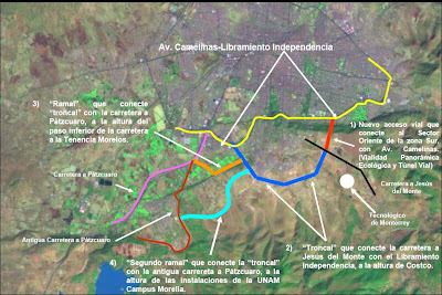
The above map shows the long range planned growth of the southern sector of Morelia. Yellow line is Avenida Camelinas. The red line is the current project known as the "Megatunnel" that will connect the city to the upper plateau where the mall, golf course, and numerous planned gated communities will be.
The dark blue shows where a perimeter road is planned connecting the tunnel extension, which would by-pass Santa Maria, El Durazno, and Fracc. Mesoamericano, ending at Libramiento Independencia near Costco (Independencia and Camelinas are one and the same, their name just changes depending on which part of the city you are in.
The brown, aqua, and red roads are planned outlets connecting to the Patzcuaro Highway. When and if all of these roads will be built is anyone's guess, but for now, the Paseo de Morelia Mall, Bosque Monarca Golf course, and tunnel project are under way and due for completion sometime in 2008.
I lifted these aerial photos off of the Morelia government's website. For a detail description of the tunnel project, including re-forestation of trees etc. visit :
http://www.morelia.gob.mx/web/Html/Hechos/Tunel%20Vial/PRESENTACIONtunelPARAinternetOK%20Abril2007.pdf
This photo shows the Cointzio Dammed lake which you can see at the bottom of the previous map.
No comments:
Post a Comment