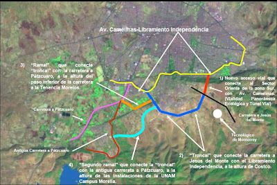
 Construction on the new "Paseo Morelia" mall keeps going, day and night. It still boggles my mind to think I will have one of the largest malls in Latin America (reported to be between 90-120,ooo square meters of construction), near my backyard. The success or failure of this depends on the access routes to be approved and built by the government. Below is a bird's eye view of where the "megatunnel" is slated to be built.
The white area in the photo to the right is where the mall is being constructed, the white curvy line cutting through the trees is where the megatunnel will be built underground. The golf course on the lower left is the Club Campestre, to give you an idea of locale.

This shot was taken from the Pope's traffic circle in January, it is hard to appreciate the immensity of this mall from afar. I guess they know their market, and I will not quarrel with Grupo GICSA's success, but with the new look "Plazas Las Americas" and the redone " Antigua Centro Caminero" (see below), I have my doubts that all this retail space can be successful.

The "old" bus station as it looks today, it is behind the " Mercado de Dulces" in Morelia center. It sits abandoned as we speak, but my memories of first arriving on an ETN bus to Morelia here live on.

The proposed new look mall at the same site (right). Supposedly, funding for its construction is due to kick in this year (2008)

The 1st stage of the "Plaza Las Americas" facelift is nearing its completion. The new half of the present plaza that includes Sears and Fabricas de F
rancia is due to open within the next month or two...or 3 or 4 :)


